Riwaka
Location: 2.0km east of the summit of State Highway 60 as it traverses Takaka Hill.
Elevation: 2953 feet AMSL (900 metres)
GPS co-ordinates for launch: -41.026335694406676, 172.8794932870903 Riwaka Launch
Rating
Paragliding: PG2
Hang gliding: ?
Wind
ENE – ESE
Access Requirements
From Nelson the launch is on the left hand side at the uphill end of the passing bay AFTER the Canaan Downs (Woolshed Café) turnoff. From Golden Bay the launch is on the right had side at the start of the passing bay after the mummified cow and the Nelson Speleological Group (NSG) Hut turnoff.
Airspace
Uncontrolled (Class G – up to 9,500 ft). There is a Mandatory Broadcast Zone (MBZ) around Motueka Airfield that extends into the Takaka/North-West Ranges foothills. Pilots may only go into this zone if using an aircraft band radio on frequency 123.7 and holding a pilot radio operator endorsement. Refer to appropriate VNC but as a rough guide, the line of the MBZ runs from Split Apple Rock, through Fraser’s Orchard in Riwaka, to the entrance of Brooklyn Valley, forming a perimeter around Motueka Aerodrome. The launch and likely flight area all fall within the Tasman CFZ (123.7). Airband radio is not compulsory in a CFZ (Common Frequency Zone).
Dangers
.
General Flying Guide
.
Landing Zones
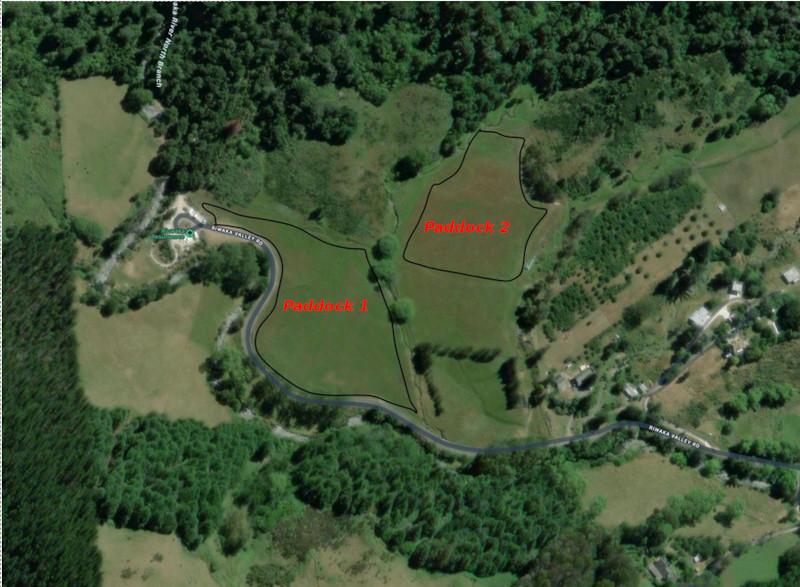
Bombout is immediately after the Riuwaka Resurgence carpark and is visible from launch. Both landing paddock s are hay paddocks. Please avoid the paddock with the longest grass. Prior to Christmas this is likely to be paddock 1. Post-Christmas this is likely to be paddock 2.
GPS co-ordinates for bombout: -41.034398112982565, 172.9032099974244 Riwaka Bombout
Mid Valley LZ
If you make it further down the valley there is an approved landing on the SW side of the road/river. There is a bridge to cross onto the farmland and the landowner is okay with landings on this gently sloping paddock. Avoid disturbing stock and leave gates as found.
GPS co-ordinates for Mid-valley LZ -41.04111264176698, 172.91047634022996 Mid-valley LZ

Riwaka Valley Left Branch LZ
This landing belongs to Hugh Drummond, who should be texted on 027 528 9878 if there’s a possibility of landing there. This is a 1:7.1 glide from launch, so normally reachable by a sky floater HG or paraglider
GPS co-ordinates for Riwaka Valley Left Branch LZ -41.049984005, 172.9203718262 Riwaka Valley Left Branch LZ

Landowners
Denise, Jason and Jacinda are supportive of free flying from their property on Takaka Hill as long as we respect their right to the peaceful enjoyment of their property and privacy, and notify them when pilots are accessing their property. With this in mind:
Conditions of use:
• For now, notification is only required of large groups, vehicles left on site or working bees.
• Notify landowners by texting Denise (021 270 1873) or Jason (020 4035 5396), prior to launch. Text should include number of pilots flying and description/number of vehicles remaining on their property during the flight, Eg: “Hi Denise, 1 Paraglider flying. Grey Subaru Outback at launch. Gordon” • Also notify landowners of any security concerns. We are their extra ‘eyes and ears’.
• Avoid overflying the dwellings on the property that are marked on the map below • A toilet has been installed by THGPA. It is the only permissible location for toileting on the property. An even better idea is to stop in at the Woolshed Café. Support a local business and make use of their toilet facilities at the same time (It is generally considered bad form to use toilets without making a purchase. Be a good person).